|
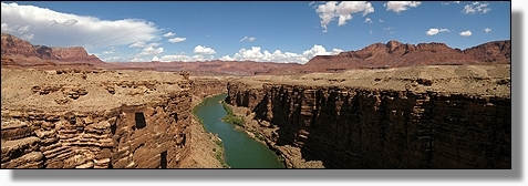
|
|
|
vom 01.09.2009 -
18.09.2009 |
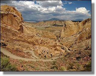
Teilstrecke 2'149 Km
Kilometer 100'889 - 103'038 |
|
|
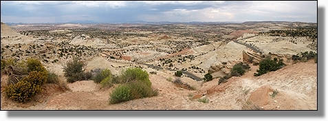
Fahrt auf dem
Highway #163
in Richtung Bluff
'Utah'
|
|
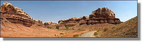
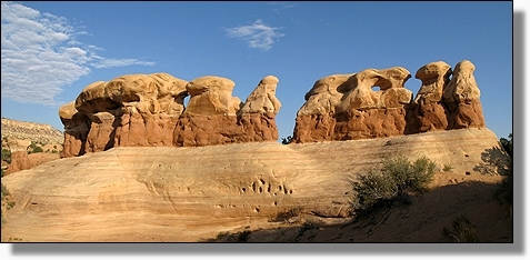
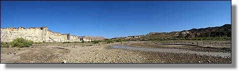
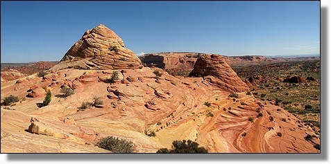
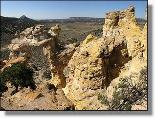
Navajo Twin Rocks
bei Bluff
'Utah' |
|
|
|
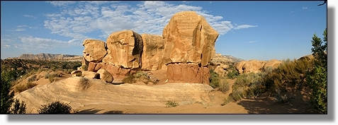
Navajo Twin Rocks
bei Bluff
'Utah'
|

|
Navajo Twin Rocks
bei Bluff 'Utah' |
|
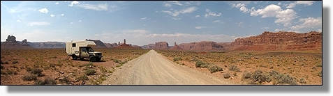
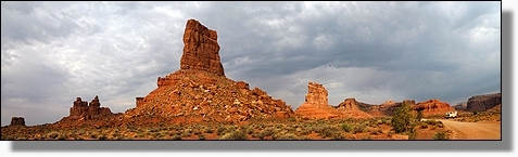
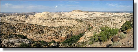
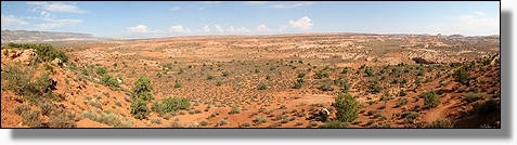
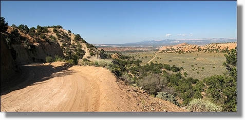
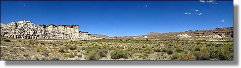
Fahrt auf der
Schotterpiste durch das
Valley of the Gods
'Utah' |
|
|
|
Valley of the Gods
'Utah' |
|
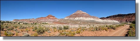
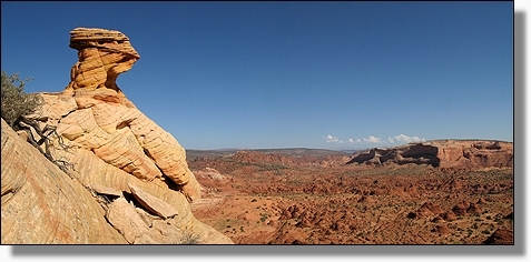
Battleship Rock,
Valley of the Gods
'Utah' |
|
|
|
Übernachtungsplatz im
Valley of the Gods
'Utah' |
|
|
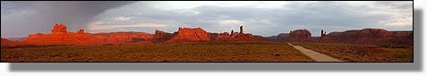
Morgenstimmung über das
Valley of the Gods
'Utah' |
|
|
|
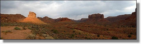
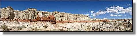
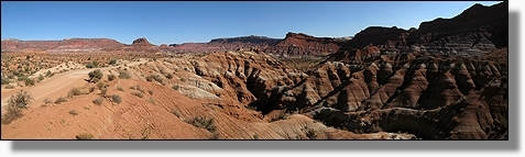
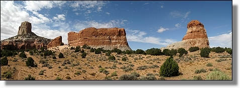
Castle Butte
Valley of the Gods
'Utah'
|
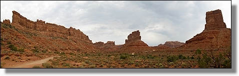
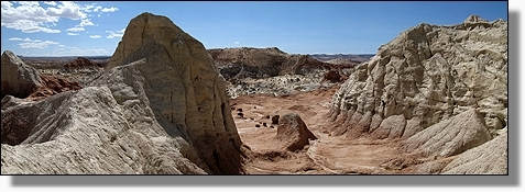
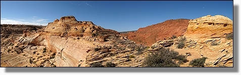
|
Valley of the Gods
'Utah'span> |
|
|
|
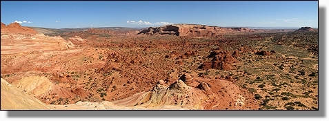
Valley of the Gods
'Utah'span> |
|
|
Valley of the Gods
'Utah' |
|
|
Valley of the Gods
'Utah' |
|
Valley of the Gods
'Utah'span> |
|
|
|
Valley of the Gods
'Utah' |
|
|
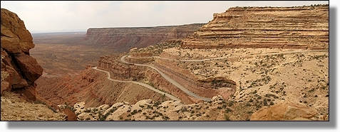
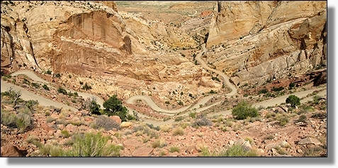
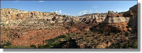
Über den Muki Dugway,
geht es auf der #261 zur Natural Bridges
'Utah' |
|
Die 2 Schweizer,
Hans und Edith,
mit ihrem Fahrrad
am
Muki Dugway
www.fahrradtour.ch
'Utah'
|
|
|
|
Blick zurück auf den
Muki Dugway 'Utah' |
|
|
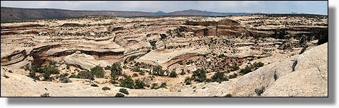
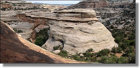
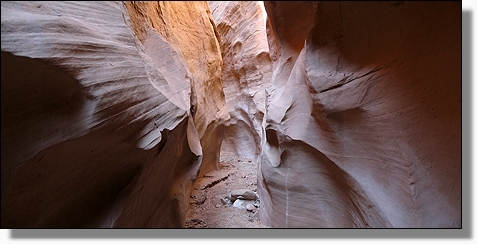
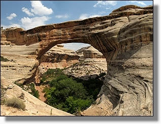
White Canyon
mit Sipapu Bridge,
im
Natural Bridges
National Monument
'Utah'
|
|
|
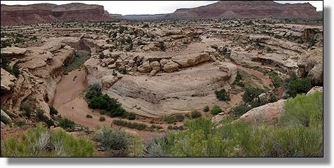
White Canyon, im Natural Bridges
National Monument
'Utah' |
|
|
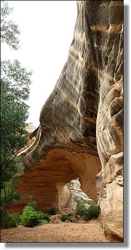
Sipapu Bridge,
im Natural Bridges
National Monument
'Utah' |
|
|
Sipapu Bridge,
im
Natural Bridges
National Monument
'Utah' |
 |
|
|
Auf dem Fussweg
durch den White Canyon, von der Sipapu zur Kachina Bridge,
im
Natural Bridges
National Monument
'Utah'
|
|
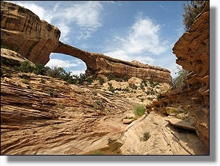
Kachina Bridge,
im
Natural Bridges
National Monument
'Utah' |
 |
|
|
und weiter durch den darauffolgenden
Armstrong Canyon
zur Owachomo Bridges,
im
Natural Bridges
National Monument
'Utah' |
|
Blick vom
Armstrong Canyon,
Natural Bridges
National Monument
'Utah' |
|
|
|
Blick vom
Armstrong Canyon,
Natural Bridges
National Monument
'Utah'
|
|
Armstrong Canyon,
Natural Bridges
National Monument
'Utah'
|
|
|
|
Erster Blick vom
Armstrong Canyon
auf die
Owachomo Bridges,
im
Natural Bridges
National Monument
'Utah'
|
|
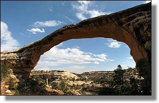
Owachomo Bridges,
im
Natural Bridges
National Monument
'Utah' |
 |
|
|
Owachomo Bridges,
im
Natural Bridges
National Monument
'Utah'
|
|
Owachomo Bridges,
im
Natural Bridges
National Monument
'Utah' |
 |
|
|
Pinyon-Juniper,
im Natural Bridges
National Monument
'Utah' |
|
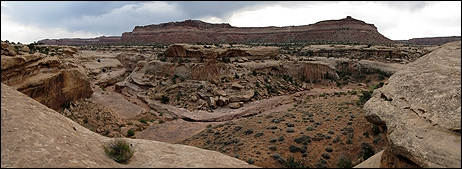
White Canyon,
im
Natural Bridges
National Monument
'Utah' |
|
|
|
Rote Sandsteinfelsen,
auf der An/Ausfahrtstrasse vom Natural Bridges
National Monument
'Utah'
|
|
Rote Sandsteinfelsen,
auf der An/Ausfahrtstrasse vom Natural Bridges
National Monument
'Utah' |
|
|
|
Fahrt auf
dem Highway #95
'Utah' |
|
|
White Canyon, entlang des Highway #95 in Richtung Hanksville
'Utah' |
|
White Canyon,
entlang des Highway #95
'Utah' |
|
|
|
White Canyon, entlang des Highway #95 in Richtung Hanksville 'Utah' |
|
|
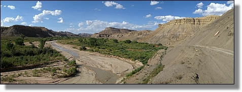
White Canyon,
in dem Glen Canyon
National Recreation Area
'Utah' |
|
Auf dem Highway #95 durch die Glen Canyon
National Recreation Area
'Utah' |
|
|
|
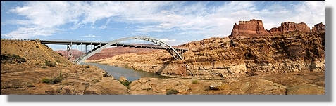
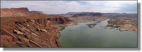
Highway #95, Brücke über den Aufgestauten Colorado River,
bei Hite, Glen Canyon
National Recreation Area
'Utah'
|
|
|
Highway #95, Brücke über den Aufgestauten Colorado River,
bei Hite, Glen Canyon
NRA
'Utah' |
|
|
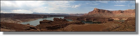
Aufgestauter Colorado River, Lake Powell, Glen Canyon
National Recreation Area
'Utah' |
|
Glen Canyon
National Recreation Area
'Utah' |
|
|
|
Aufgestauter Colorado River, Lake Powell, gegenüber Hite, Glen Canyon NRA
'Utah' |
|
|
Glen Canyon
National Recreation Area
'Utah' |
|
|
Auf dem Highway #95
'Utah' |
|
Mt. Hillers,
am Highway #276
nach Bullfrog
'Utah' |
|
|
|
Auf dem Highway #276
'Utah' |
|
Sicht von der
Burr Trail Road, auf den Muley Creek
'Utah' |
|
|
|
Sicht von der
Burr Trail Road
'Utah'
|
|
Auf der
Burr Trail Road
'Utah' |
|
|
|
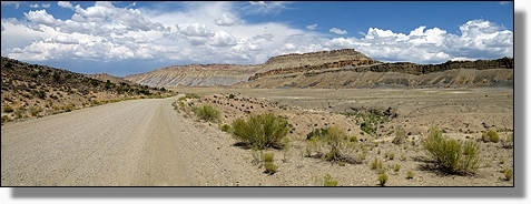
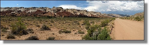
Auf der geschotterten
Burr Trail Road, in Richtung Capitol Reef National Park
'Utah' |
|
|
Auf der Burr Trail Road, im Capitol Reef National Park 'Utah' |
|
|
Sicht auf den
Surprise Canyon,
im Capitol Reef
National Park
'Utah'
|
|
Auf dem Fussweg zum
Surprise Canyon,
im Capitol Reef
National Park
'Utah' |
|
|
|
Surprise Canyon,
im Capitol Reef
National Park
'Utah'
|
|
Surprise Canyon,
im Capitol Reef
National Park
'Utah' |
|
 |
Sicht zurück auf die
Burr Trail Switchbacks,
im Capitol Reef
National Park
'Utah'
|
|
|
Burr Trail Switchbacks,
im Capitol Reef
National Park
'Utah' |
|
Auf der
Burr Trail Road,
im Capitol Reef
National Park
'Utah' |
|
|
|
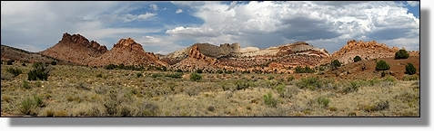
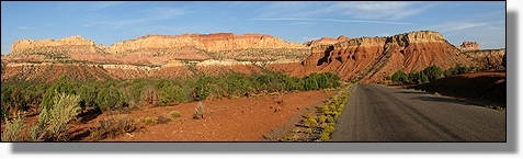
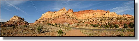
Capitol Reef
National Park
'Utah' |
|
|
Capitol Reef
National Park
'Utah'
|
|
Sicht vom Burr Trail
auf die
Circle Cliffs,
im Grand
Staircase-Escalante National Monument
'Utah' |
|
|
|
Sicht vom Burr Trail
auf die
Circle Cliffs,
im Grand
Staircase-Escalante National Monument 'Utah' |
|
|
Circle Cliffs,
im Grand
Staircase-Escalante National Monument
'Utah'
|
|
|
Circle Cliffs,
im Grand
Staircase-Escalante National Monument
'Utah' |
|
Durch den Long Canyon des Burr Trail
nach Boulder,
im Grand
Staircase-Escalante National Monument
'Utah' |
|
|
|
Sicht vom Scenic Byway #12,
Grand Staircase-Escalante National Monument 'Utah' |
|
|
Sicht vom
Scenic Byway #12,
Grand Staircase-Escalante National Monument
'Utah'
|
|
|
Sicht vom
Scenic Byway #12,
Grand Staircase-Escalante National Monument
'Utah' |
|
|
Auf dem Fussweg zum Lower Calf Creek Falls,
Grand Staircase-Escalante NM. 'Utah' |
|
|
Auf dem Lower Calf Creek Falls Trail, Grand Staircase-Escalante NM. 'Utah'
|
|
Sicht vom
Lower Calf Creek
Falls Trail,
Grand Staircase-Escalante
National Monument
'Utah'
|
|
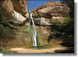 |
Lower Calf Creek Falls,
Grand e-Escalante
National Monument
'Utah'
|
|
Lower Calf Creek Falls,
Grand Staircase-Escalante
National Monument
'Utah'
|
|
|
|
Sicht vom
Lower Calf Creek
Falls Trail,
Grand aircase-Escalante
National Monument
'Utah'
|
|
Ca.1'000 Jahre alte Piktogramme in der nähe des Lower Calf
Creek Falls Trail,
Grand aircase-Escalante
National Monument
'Utah'
|
|
|
|
Entlang des Escalante Rivers zur
Escalante Natural Bridge und Arch, Staircase-Escalante
National Monument
'Utah'
|
|
Escalante Natural
Bridge,
Grand Staircase-Escalante
National Monument
'Utah'
|
|
|
|
Escalante Natural Bridge,
Grand Staircase-Escalante
National Monument
'Utah'
|
|
Escalante Natural
Bridge,
Grand Staircase-Escalante
National Monument
'Utah'
|
 |
|
|
Der Weg führt immer wieder durch
den Escalante Rivers.
Grand Staircase-Escalante
National Monument
'Utah'
|
|
Escalante
Natural Arch,
Grand Staircase-Escalante
National Monument
'Utah'
|
|
|
|
Die in einer Felsnische gelegenen
Anasazi Ruinen, bei der
Escalante Natural Arch,
Grand Staircase-Escalante
National Monument
'Utah'
|
|
Anasazi Ruinen,
bei der
Escalante Natural Arch,
Grand Staircase-Escalante
National Monument
'Utah'
|
|
|
|
Auf diesem Wanderweg gab es immer
wieder den Escalante Rivers
zu durch waten.
Grand Staircase-Escalante National Monument
'Utah'
|
|
|
Aussicht vom Scenic Byway #12, Grand Staircase-Escalante
National Monument 'Utah' |
|
Am Wegrand gelegener Hoodoo, Scenic Byway #12,
Grand Staircase-Escalante
National Monument
'Utah' |
|
|
|
Am Wegrand gelegene Hoodoos,
Scenic Byway #12,
Grand Staircase-Escalante
National Monument
'Utah'
|
|
Übernachtungsplatz
in der nähe des
Scenic Byway #12,
Grand Staircase-Escalante
National Monument
'Utah' |
|
|
|
Der am Hole-in-the-Rock-Road gelegende Devils Garden, Grand Staircase-Escalante
NM.
'Utah'
|
|
|
Devils Garden,
Grand Staircase-Escalante National Monument
'Utah'
|
|
|
Felsformationen des
Devils Garden,
Grand Staircase-Escalante National Monument 'Utah' |
|
Devils Garden,
Grand Staircase-Escalante National Monument
'Utah'
|
|
|
|
Devils Garden,
Grand Staircase-Escalante National Monument
'Utah'
|
|
Devils Garden,
Grand Staircase-Escalante National Monument
'Utah'
|
|
|
|
Metate Arch im
Devils Garden,
Grand Staircase-Escalante National Monument
'Utah'
|
|
|
Sandsteinfelsen des
Devils Garden,
Grand Staircase-Escalante National Monument 'Utah' |
|
|
Aussicht von der
Hole-in-the-Rock-Road, Grand Staircase-Escalante NM. 'Utah' |
|
Auf dem Fussweg
zu den 3 Slot Canyons,
an der
Hole-in-the-Rock-Road,
Grand Staircase-Escalante National Monument
'Utah' |
|
|
|
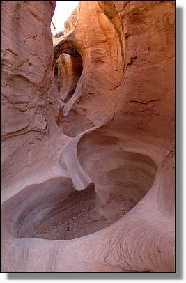
Eingang zum
Slot Canyon
Grand Staircase-Escalante National Monument
'Utah'
|
|
|
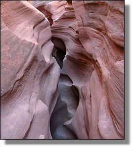
Im Slot Canyon der keinen Namen hat,
Grand Staircase-Escalante National Monument
'Utah' |
|
Im Slot Canyon
der keinen Namen hat,
Grand Staircase-Escalante National Monument
'Utah' |
|
|
|
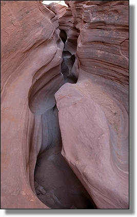
Echse, im Slot Canyon
der keinen Namen hat,
Grand Staircase-Escalante
National Monument
'Utah' |
|
Im Slot Canyon
der keinen Namen hat,
Grand Staircase-Escalante National Monument
'Utah' |
|
|
|
Im Slot Canyon
der keinen Namen hat,
Grand Staircase-Escalante
National Monument
'Utah'
|
|
Eingang zum
spektakulären
Peek-A-Boo Slot Canyon,
Grand Staircase-Escalante National Monument
'Utah' |
|
 |
Peek-A-Boo Slot Canyon,
Grand Staircase-Escalante
National Monument.
'Utah'
|
|
Peek-A-Boo Slot Canyon,
Grand Staircase-Escalante
National Monument.
'Utah' |
 |
|
|
Klettertour durch den
Peek-A-Boo Slot Canyon,
Grand Staircase-Escalante
National Monument.
'Utah'
|
|
Peek-A-Boo Slot Canyon,
Grand Staircase-Escalante
National Monument.
'Utah' |
|
|
|
Mag ich da wohl durch mit meinem Rucksack?,
Peek-A-Boo Slot Canyon,
Grand Staircase-Escalante
National Monument.
'Utah'
|
|
Peek-A-Boo Slot Canyon,
Grand Staircase-Escalante
National Monument.
'Utah' |
|
|
|
Für Adrian ist das keine Sache!!!
Peek-A-Boo Slot Canyon,
Grand Staircase-Escalante
National Monument.
'Utah'
|
|
Peek-A-Boo Slot Canyon,
Grand Staircase-Escalante
National Monument.
'Utah' |
|
 |
Peek-A-Boo Slot Canyon,
Grand Staircase-Escalante
National Monument.
'Utah'
|
|
Jean-Pierre hat die richtige Postur für diesen Canyon,
Peek-A-Boo Slot Canyon,
Grand Staircase-Escalante
National Monument.
'Utah' |
|
 |
Peek-A-Boo Slot Canyon,
Grand Staircase-Escalante
National Monument.
'Utah'
|
|
Nach der sensationellen und spasigen Durchquerung wieder an der
frischen Luft,
Peek-A-Boo Slot Canyon,
Grand Staircase-Escalante
National Monument.
'Utah' |
|
|
|
Sicht über den verborgenen
Peek-A-Boo Slot Canyon,
Grand Staircase-Escalante
National Monument.
'Utah'
|
|
Eingang zum sehr engen Spooky Slot Canyon,
Grand Staircase-Escalante
National Monument.
'Utah' |
|
|
|
Spooky Slot Canyon,
Grand Staircase-Escalante
National Monument.
'Utah'
|
|
Spooky Slot Canyon,
Grand Staircase-Escalante
National Monument.
'Utah' |
|
|
|
Spooky Slot Canyon,
Grand Staircase-Escalante
National Monument.
'Utah'
|
|
Nicht für an Klaustrophobie leidende Leute, ist der
Spooky Slot Canyon,
Grand Staircase-Escalante
National Monument.
'Utah' |
|
|
|
Blick über das Gebiet dieser drei Slot Canyons,
an der
Hole-in-the-Rock-Road,
Grand Staircase-Escalante National Monument
'Utah'
|
|
Wüstenhaase,
Grand Staircase-Escalante National Monument
'Utah' |
|
|
|
Rückfahrt auf der
Hole-in-the-Rock-Road,
Grand Staircase-Escalante National Monument
'Utah'
|
|
Hole-in-the-Rock-Road,
Grand Staircase-Escalante National Monument
'Utah' |
|
|
|
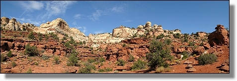
Erste schöne Sandsteinformationen
am Tropic Canyon,
Bryce Canyon
National Park
'Utah'
|
|
Sandsteinformationen
am Tropic Canyon,
Bryce Canyon
National Park
'Utah' |
|
|
|
Tropic Ditch Fall,
Bryce Canyon
National Park
'Utah'
|
|
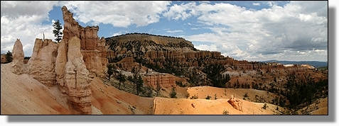
Farbenfroher Blick,
vom Sunset Point
über das
Bryce Amphitheater,
Bryce Canyon
National Park
'Utah' |
|
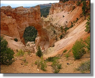 |
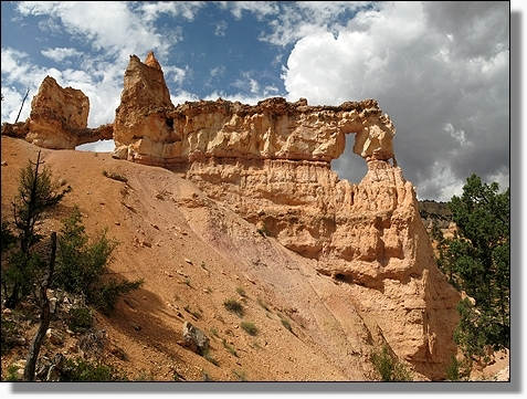
Natural Bridge,
Bryce Canyon
National Park
'Utah' |
|
Blick vom, am Rainbow Point gelegenen Bristlecone
Loop Trail,
(Mit 2778m höchster Punkt im Park)
Bryce Canyon
National Park
'Utah' |
|
|
|
Bristlecone Loop Trail,
Bryce Canyon
National Park
'Utah'
|
|
Aussicht vom
Rainbow Point,
Bryce Canyon
National Park
'Utah' |
|
|
|
Blick über den
Agua Canyon,
Bryce Canyon
National Park
'Utah'
|
|
|
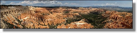
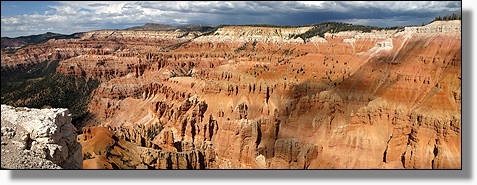
Grossartiger Blick vom Bryce Point,
Bryce Canyon
National Park
'Utah'
|
|
|
Auf dem Fairyland Loop Trail, durch den Bryce Canyon
National Park
'Utah'
|
|
Tower Bridge, am Fairyland Loop Trail, Bryce Canyon
National Park
'Utah'
|
|
Auf dem Fairyland Loop Trail, Bryce Canyon
National Park
'Utah'
|
|
|
|
Aussicht vom Fairyland Loop Trail, auf die märchenhafte Landschaft
des Bryce Canyon
National Park
'Utah'
|
|
Aussicht
vom Fairyland Point,
Bryce Canyon
National Park
'Utah'
|
|
|
|
Sicht von der
Cottonwood Canyon Road,
Grand Staircase-Escalante National Monument
'Utah'
|
|
Fahrt auf der
Cottonwood Canyon Road, durch das
Grand Staircase-Escalante National Monument
'Utah' |
|
|
|
Sicht von der
Cottonwood Canyon Road,
Grand Staircase-Escalante National Monument
'Utah' |
|
|
Blick zurück über die Cottonwood Canyon Road,
Grand Staircase-Escalante NM.
'Utah' |
|
|
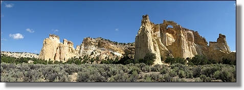
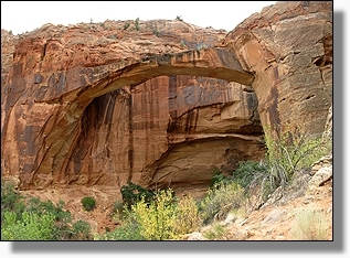
Die Felsformation mit der Grosvenor Arch, Grand Staircase-Escalante National Monument
'Utah' |
 |
Auf dem Top,
mit Blick durch die
Grosvenor Arch,
Grand Staircase-Escalante National Monument
'Utah'
|
|
Grosvenor Arch,
Grand Staircase-Escalante National Monument
'Utah' |
|
|
|
Durch die Grosvenor Arch, über das
Grand Staircase-Escalante
National Monument
'Utah'' |
|
Grosvenor Arch,
Grand Staircase-Escalante
National Monument
'Utah' |
|
|
|
Sicht auf das schokoladenfarbige
Gestein an der
Cottonwood Canyon Road,
Grand Staircase-Escalante National Monument
'Utah' |
|
Auf der
Cottonwood Canyon Road,
Grand Staircase-Escalante National Monument
'Utah' |
|
|
|
Die Fahrt führt uns durch herrlicher Umgebung.
Cottonwood Canyon Road,
Grand Staircase-Escalante National Monument
'Utah' |
|
Zu Fuss durch die
North Cottonwood Narrows,
Grand Staircase-Escalante
National Monument
'Utah' |
|
|
|
North Cottonwood Narrows,
Grand Staircase-Escalante
National Monument
'Utah'
|
|
Weiter auf der
Cottonwood Canyon Road
in Richtung Big Water,
Grand Staircase-Escalante National Monument
'Utah' |
|
|
|
South Cottonwood Narrows,
Grand Staircase-Escalante
National Monument
'Utah'
|
|
Entlang der
Cottonwood Canyon Road,
Grand Staircase-Escalante National Monument
'Utah' |
|
|
|
Sicht von der
Cottonwood Canyon Road,
Grand Staircase-Escalante National Monument
'Utah' |
|
Blick über die
Cottonwood Canyon Road,
Grand Staircase-Escalante National Monument
'Utah' |
|
|
|
Cottonwood Canyon Road,
Grand Staircase-Escalante National Monument
'Utah'
|
|
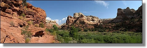
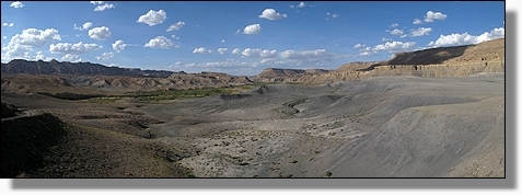
Unser Fussmarsch führte einige Kilometer in den Lower Hackberry Creek
Canyon hinein,
Grand Staircase-Escalante National Monument
'Utah' |
|
|
|
Im Lower Hackberry Creek Canyon,
Grand Staircase-Escalante
National Monument
'Utah' |
|
Lower Hackberry Creek Canyon,
Grand Staircase-Escalante
National Monument
'Utah' |
|
|
|
Lower Hackberry Creek Canyon,
Grand Staircase-Escalante
National Monument
'Utah'
|
|
Wieder zurück beim Aus/Eingang des Lower Hackberry Creek
Canyon,
Grand Staircase-Escalante
National Monument
'Utah' |
|
|
|
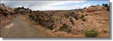
Auf immer holpriger werdender Strasse durch den
Cottonwood Canyon,
Grand Staircase-Escalante National Monument
'Utah'
|
|
Cottonwood Canyon Road,
Grand Staircase-Escalante National Monument
'Utah' |
|
|
|
Blick über den Paria River,
Grand Staircase-Escalante National Monument
'Utah' |
|
|
Sicht von der
Cottonwood Canyon Road,
Grand Staircase-Escalante National Monument
'Utah' |
|
|
Zum Schluss ging es nochmals zur
Sache, auf der
Cottonwood Canyon Road,
Grand Staircase-Escalante National Monument
'Utah'
|
|
|
Auf dem Wanderpfad entlang des Wahweap Creek, zu den White Ghosts
Hoodoos
'Utah' |
|
Auf dem Fussweg ins Valley of White Ghosts
'Utah' |
|
|
|
Erste Hoodoos des
Wahweap Creek
'Utah' |
|
Valley of White Ghosts,
am Wahweap Creek
'Utah' |
|
|
|
Valley of White Ghosts,
'Utah'
|
|
Wahweap
Hoodoos,
im
Valley of
White Ghosts,
'Utah' |
|
|
|
Wahweap
Hoodoos,
im
Valley of
White Ghosts,
'Utah'
|
|
Der sogenannte
White Ghosts
'Utah' |
|
|
|
Wahweap
Hoodoos,
im
Valley of
White Ghosts,
'Utah'
|
|
Valley of White Ghosts,
am Wahweap Creek
'Utah' |
|
|
|
Wahweap
Hoodoos,
im
Valley of
White Ghosts,
'Utah'
|
|
|
Auf dem Rückweg von den White Ghosts Hoodoos 'Utah' |
|
Zurück durch den Wahweap Creek
'Utah' |
|
|
|
Auf dem Fussweg zu den
Toad Stools
'Utah'
|
|
Weitere Hoodoos in der
Umgebung der
Toad Stools
'Utah' |
|
|
|
Die
Umgebung der
Toad Stools
'Utah'
|
|
|
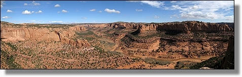
Panoramablick über die Felsformationen der
Toad Stools
'Utah' |
|
|
Felslandschaft bei den Toad Stools
'Utah' |
|
Die
Umgebung der
Toad Stools
'Utah' |
|
 |
Felslandschaft bei den Toad Stools
'Utah'
|
|
Die
Umgebung der
Toad Stools
'Utah' |
|
|
|
Hoodoo in der
Umgebung der
Toad Stools
'Utah'
|
|
|
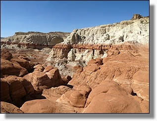
Die schokoladenfarbigen Badlands bei der Old Pahreah 'Utah' |
|
|
Die farbenfrohe Landschaft bei
Old Pahreah
'Utah' |
|
Auf dem Wanderweg zur stark regulierten
"The Wave"
mit nur 20 Personen
pro Tag, in der
Coyote Buttes North
des
Paria Canyon Vermilion Cliffs Wilderness
die in Utah/Arizona liegt
'Utah' |
|
|
|
Sicht vom Wanderweg zur The Wave, im
Coyote Buttes North
'Utah' |
|
|
Auf dem Wanderweg zur The Wave, im
Coyote Buttes North
'Utah'
|
|
|
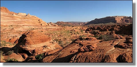
Die herrliche Felswildnis auf dem Wanderweg zur The Wave, im Coyote Buttes
North
'Utah' |
|
Auf dem Wanderweg zur The Wave, im
Coyote Buttes North
'Utah' |
|
|
|
Auf dem Wanderweg zur The Wave, im
Coyote Buttes North
'Utah'
|
|
|
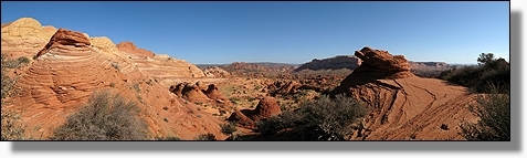
Auf dem Wanderweg zur The Wave, im Coyote Buttes North
'Utah' |
|
Auf dem Wanderweg zur The Wave, im
Coyote Buttes North
'Utah' |
|
|
|
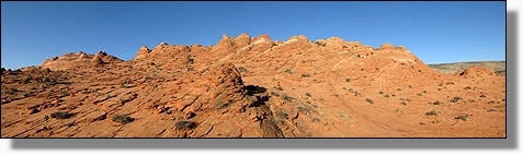
Faszinierende Felslandschaft auf dem Weg zur The Wave, im Coyote Buttes
North
'Utah' |
|
|
Auf dem Wanderweg zur The Wave,
im
Coyote Buttes North
'Utah'
|
|
Auf dem Wanderweg zur The Wave, im
Coyote Buttes North
'Utah' |
|
|
|
Auf dem Wanderweg zur The Wave, im Coyote Buttes North
'Utah' |
|
|
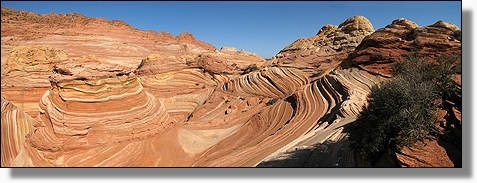
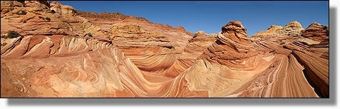
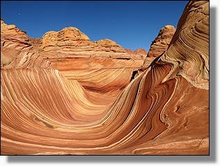
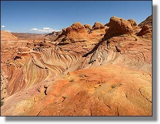
The Wave,
im
Coyote Buttes North
'Arizona'
|
|
The Wave,
im
Coyote Buttes North
'Arizona' |
|
|
|
The Wave,
im
Coyote Buttes North
'Arizona'
|
|
The Wave,
im
Coyote Buttes North
'Arizona' |
 |
|
|
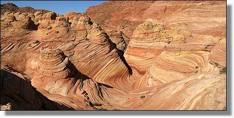
The Wave,
im
Coyote Buttes North
'Arizona'
|
|
The Wave,
im
Coyote Buttes North
'Arizona' |
|
|
|
The Wave,
im
Coyote Buttes North
'Arizona'
|
|
The Wave,
im
Coyote Buttes North
'Arizona' |
|
|
|
The Wave,
im Coyote Buttes North
'Arizona' |
|
|
The Wave,
im Coyote Buttes North
'Arizona' |
|
|
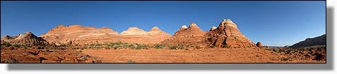
Blumenkohlartiger Sandstein in der Umgebung der
The Wave,
im
Coyote Buttes North
'Arizona'
|
|
|
Umgebung der
The Wave,
im Coyote Buttes North
'Arizona' |
|
|
Umgebung der
The Wave,
im Coyote Buttes North
'Arizona' |
|
|
Umgebung der The Wave, im Coyote Buttes North 'Arizona' |
|
Blick von einem nahegelegenen Felsen in die
The Wave,
im
Coyote Buttes North
'Arizona' |
|
|
|
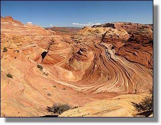
Blich von hoch oben auf die Sandsteinformationen The Wave,
im
Coyote Buttes North
'Arizona'
|
|
|
Umgebung der
The Wave,
im Coyote Buttes North
'Arizona' |
|
Umgebung der
The Wave,
im
Coyote Buttes North
'Arizona' |
|
 |
The Wave,
im
Coyote Buttes North
'Arizona'
|
|
The Wave,
im
Coyote Buttes North
'Arizona' |
|
|
|
The Wave,
im Coyote Buttes North
'Arizona' |
|
|
Weitere Sandsteinformationen in der Umgebung der
The Wave,
im
Coyote Buttes North
'Arizona'
|
|
|
Umgebung der
The Wave,
im Coyote Buttes North
'Arizona' |
|
Umgebung der
The Wave,
im
Coyote Buttes North
'Arizona' |
 |
|
|
Umgebung der
The Wave,
im
Coyote Buttes North
'Arizona'
|
|
Umgebung der
The Wave,
im
Coyote Buttes North
'Arizona' |
|
|
|
Umgebung der
The Wave,
im
Coyote Buttes North
'Arizona'
|
|
Umgebung der
The Wave,
im
Coyote Buttes North
'Arizona' |
|
|
|
Kuchenteigfabrik der Natur, Umgebung der
The Wave,
im
Coyote Buttes North
'Arizona'
|
|
Die an Schokolade Madeleine erinnernde Sandsteinformation,
in Umgebung der
The Wave,
im
Coyote Buttes North
'Arizona' |
|
|
|
Schokolande-Madeleine bei der The Wave,
im
Coyote Buttes North
'Arizona' |
|
Auf dem Rückweg der unvergesslichen Landschaft von der
The Wave,
im
Coyote Buttes North
'Utah/Arizona' |
|
|
|
Auf dem Wire Pass Trail,
Coyote Buttes Nort
'Utah' |
|
Durch den
Wire Pass Gulch,
zum Buckskin Gulch,
Coyote Buttes North
'Utah' |
|
|
|
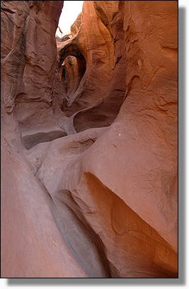
Wire Pass Gulch,
ein weiterer interessanter Slot Canyon,
Coyote Buttes North
'Utah'
|
|
Wire Pass Gulch,
Coyote Buttes North
'Utah' |
|
|
|
Der Ausgang des
Wire Pass Gulch,
Coyote Buttes North
'Utah'
|
|
Gleich weiter ging es in den
Buckskin Gulch,
Coyote Buttes North
'Utah' |
|
|
|
Der zum Teil noch schlammige
Buckskin Gulch,
Coyote Buttes North
'Utah'
|
|
Buckskin Gulch,
Coyote Buttes North
'Utah' |
|
|
|
Buckskin Gulch,
Coyote Buttes North
'Utah'
|
|
Buckskin Gulch,
Coyote Buttes North
'Utah' |
|
|
|
Der an einen Elefanten erinnernde
Sandsteinfelsen, im
Buckskin Gulch,
Coyote Buttes North
'Utah'
|
|
Buckskin Gulch Trail,
Coyote Buttes North
'Utah' |
|
|
|
Auf der wie nicht anders als erwarteten sehr
holprigen
Houserock Valley Road, ging es zurück zum Highway #89,
Coyote Buttes North
'Utah'
|
|
Nein Nein
nicht der Bryce Canyon,
hier handelt es sich um das Cedar Breaks National Monument, dass in
einer Höhe von über
3100m liegt
'Utah' |
|
|
|
Das Amphitheater des
Cedar Breaks
National Monument
'Utah'
|
|
Cedar Breaks
National Monument
'Utah' |
|
|
|
Cedar Breaks
National Monument
'Utah'
|
|
|
Das Amphitheater des
Cedar Breaks
National Monument
'Utah' |
|
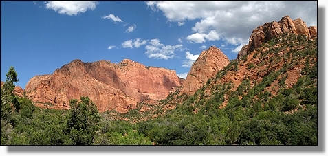
Aussicht von der Wanderung zur
Kolob Arch,
im Kolob Canyon Bereich, des Zion National Park
'Utah' |
|
|
|
Entlang des La Verkin Creek zur
Kolob Arch,
Zion National Park
'Utah'
|
|
Auf dem Weg zur
Kolob Arch,
Zion National Park
'Utah' |
 |
|
|
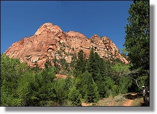
Zion National Park
'Utah'
|
|
Kolob Arch,
mit 95m Spanweite
soll es der grösste
Felsbogen der Welt sein,
Zion National Park
'Utah' |
|
|
|
Zion National Park
'Utah' |
|
|
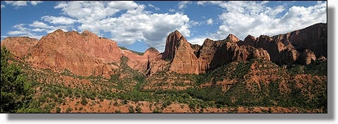
Kolob Canyon, des Zion National Park
'Utah' |
|
|
Auf der
Kolob
Canyon Road,
des Zion National Park
'Utah'
|
|
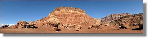
Pipe Spring
National Monument
Quelle /
Handelsposten / Ranch,
wahr lange Zeit in Mormonen Besitz
'Arizona' |
|
|
|
Winsor Castle.
nach dem ersten Manager benant,
Pipe Spring
National Monument
'Arizona'
|
|
Winsor Castle,
Pipe Spring
National Monument
'Arizona' |
|
|
|
Pipe Spring
National Monument
'Arizona' |
|
Pipe Spring
National Monument
'Arizona' |
|
|
|
Texas Longhorn Cattle,
Pipe Spring
National Monument
'Arizona' |
|
Schmiede,
Pipe Spring
National Monument
'Arizona' |
|
|
|
Bevor das Castle fertig gebaut war,
bestand schon eine Telegraphenverbringung zum Hauptquartier der
Mormonen in
Salt Lake City.
Pipe Spring
National Monument
'Arizona' |
|
Rhinosaurus Beetle,
Pipe Spring
National Monument
'Arizona' |
|
|
|
Die am Bright Angel
Point gelegene
Grand Canyon Lodge
aus dem Jahr 1937,
am North Rim des
Grand Canyon
National Park
'Arizona' |
|
|
Vom Bright Angel Point in den Grand Canyon,
North Rim des
Grand Canyon
NP.
'Arizona' |
|
North Rim Grand Canyon National Park.
'Arizona' |
|
|
|
Vom Bright Angel Point
in den Grand Canyon,
North Rim des
Grand Canyon
National Park
'Arizona' |
|
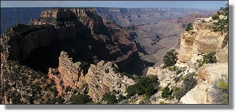
Blick vom Cape Royal in den Grand Canyon,
North Rim des
Grand Canyon
National Park
'Arizona' |
|
|
|
Blick vom Cape Royal über den Wotans Throne in den Grand Canyon,
Grand Canyon NP. 'Arizona' |
|
|
Blick vom Cape Royal in den Grand Canyon,
North Rim des
Grand Canyon
National Park
'Arizona'
|
|
Angels Window
am Cape Royal,
North Rim des
Grand Canyon
National Park
'Arizona' |
|
|
|
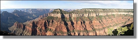
Blick vom
Walhalla Overlook
in den Grand Canyon,
North Rim des
Grand Canyon
National Park
'Arizona'
|
|
Walhalla Glades Ruine,
North Rim des
Grand Canyon
National Park
'Arizona' |
|
|
|
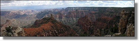
Der schönste Ausblick am North Rim, fanden wir am
Point Imperial,
Grand Canyon NP. 'Arizona' |
|
|
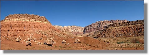
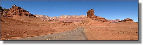
Entlang der Vermilion Cliffs und dem Highway #89A nähern wir
uns Marble Canyon
'Arizona' |
|
|
Balancierender Felsen beim
House Rock am Highway #89A
'Arizona' |
|
Balancierende
Felsen beim
House Rock,
am Highway #89A
'Arizona' |
|
|
|
Das an Fred Feuerstein erinnernde Steinhaus,
House Rock,
am Highway #89A
'Arizona'
|
|
|
House Rock,
gebaut um 1930,
am Highway #89A
'Arizona' |
|
|
Vermilion Cliffs und dem Highway #89A nähern wir uns Marble Canyon
'Arizona' |
|
|
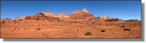
Vermilion Cliffs am Highway #89A 'Arizona' |
|
|
Vermilion Cliffs, auf dem Weg nach Lees Ferry am Colorado
River
'Arizona' |
|
Balanced Rock,
auf dem Weg
nach Lees Ferry,
in der Glen Canyon National Recreation Area
'Arizona' |
|
|
|
Balanced Rock,
in der Glen Canyon National Recreation Area
'Arizona'
|
|
Anlegeplatz der Schlauchboote am Colorado River
in Lees Ferry,
in der Glen Canyon National Recreation Area
'Arizona' |
|
|
|
Lees Ferry Fort
von 1874,
in
Lees Ferry,
in der Glen Canyon National Recreation Area
'Arizona'
|
|
Colorado River bei
Lees Ferry,
in der Glen Canyon National Recreation Area
'Arizona' |
|
|
|
Wagemutige oder auch nicht auf dem
Colorado River,
in der Glen Canyon National Recreation Area
'Arizona'
|
|
Glen Canyon National Recreation Area
'Arizona' |
|
|
|
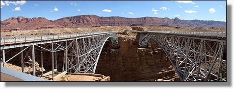
Navajo Bridge über den Colorado River, Highway #89A
'Arizona' |
|
|
Vom
Highway #89A, auf der
Navajo Bridge, über den Colorado River 'Arizona' |
|
|
Indianer Souvenirstände
bei einem Aussichtspunkt
der Echo Cliffs
am Highway #89
'Arizona'
|
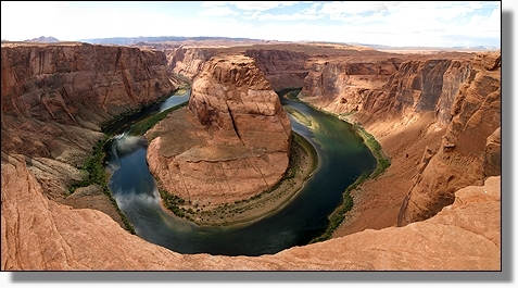
|
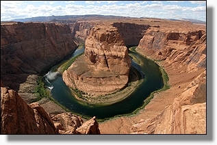
Sicht auf den Colorado River, beim Horseshoe Bend, nähe Page
am Highway #89
'Arizona' |
 |
|
|
Sicht auf den Colorado River, beim Horseshoe Bend, nähe Page
am Highway #89
'Arizona' |
|
|
Durch den
Glen Canyon Dam, wird der Colorado River zum
Lake Powell
aufgestaut,
bei Page
'Arizona'
|
|
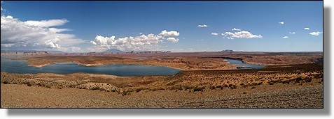
|
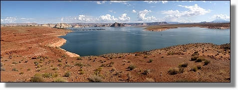
Lake Powell, in
der Glen Canyon National Recreation Area
'Arizona' |
|
|
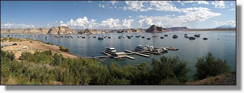
Wahweap Bereich des
Lake Powell, in der Glen Canyon National Recreation Area 'Arizona' |
|
Rampe bei Wahweap
am
Lake Powell, in der Glen Canyon National Recreation Area
'Arizona' |
|
|
|
Lake Powell, in der
Glen Canyon National Recreation Area
'Arizona'
|
|
|
Lake Powell, in der Glen Canyon National Recreation Area
'Arizona' |
|
Hanging Garden,
in der Glen Canyon National Recreation Area
'Arizona' |
|
|
|
Sicht von den Hanging Garden, auf den
Lake Powell,
in der Glen Canyon National Recreation Area
'Arizona'
|
|
Sicht von den
Hanging Garden,
in der Glen Canyon National Recreation Area
'Arizona' |
|
|
|
Glen Canyon Dam
bei Page
'Arizona'
|
|
Blick auf dem Upper Antelope Canyon, bei Page
'Arizona'
|
|
|
|
Felsformationen entlang des Highway #98
'Arizona'
|
|
|
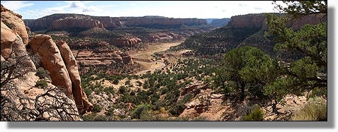
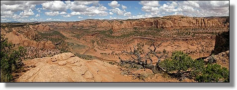
Über Shonto führt eine Schotterpiste in das Navajo National Monument
'Arizona'
|
|
|
Die in den Sandsteinfelsen gut versteckte Betatakin Ruine,
Navajo National Monument 'Arizona'
|
|
|
Auf dem Wanderweg zur
Betatakin Ruine,
Navajo
National Monument
'Arizona'
|
|
|
Auf dem Wanderweg zur
Betatakin Ruine,
Navajo
National Monument 'Arizona'
|
|
|
Auf dem Wanderweg zur
Betatakin Ruine,
Navajo
National Monument
'Arizona'
|
|
Blick in den Betatakin Canyon,
vom Wanderweg zur
Betatakin Ruine,
Navajo
National Monument
'Arizona'
|
|
|
|
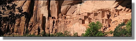
Die gut getarnte
Betatakin Ruine,
Navajo
National Monument
'Arizona' |
|
|
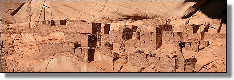
Betatakin Ruine,
Navajo
National Monument
'Arizona'
|
|
Betatakin Ruine,
Navajo
National Monument
'Arizona' |
|
|
|
Felsmalereien
im Alkoven
der Betatakin Ruine,
Navajo
National Monument
'Arizona'
|
|
|
Die sehr gut erhaltene
Betatakin Ruine,
Navajo
National Monument
'Arizona' |
|
Betatakin Ruine,
Navajo
National Monument
'Arizona' |
|
|
|
Betatakin Ruine,
Navajo
National Monument
'Arizona'
|
|
Betatakin Ruine,
Navajo
National Monument
'Arizona' |
|
|
|
Auf dem Rückweg
von der Betatakin Ruine,
Navajo
National Monument
'Arizona'
|
|
|
Navajo
National Monument 'Arizona' |
|
Nach der interessanten Wandern, gab's auf dem Campingplatz des
Navajo
National Monument
eine kleine Wäsche
'Arizona' |
|
|
|
In weniger als einer Stunde und
schon alles trocken,
Campingplatz des
Navajo
National Monument
'Arizona'
|
|
Sandsteinfelsen am Highway #160 in Richtung New
Mexico
'Arizona'
|
|
|
|
Sandsteinfelsen am Highway #160 in Richtung New
Mexico
'Arizona'
|
|